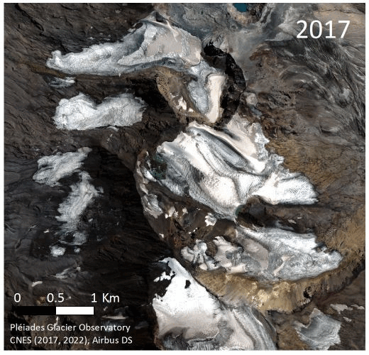
Repeat Pléiades images over the Andes

Since 2021, the PGO has entered a « revisit » mode. In other words, the Pleiades satellites photograph the same glaciers 5 years later to study their change in extent and volume. Thus, in February and March 2022, Pleiades acquired stereo images of about 15 glaciated sites in the Southern Hemisphere that had already been observed in February and March 2017.

Among these targets, the glaciers of the Peteroa volcano area are seen on the attached animation. The retreat is edifying, perfectly palpable in only 5 years. The poor health of these glaciers is also evidenced by the small proportion of their surface that is covered by snow: indeed, the ice outcrops almost everywhere. The next step will be to estimate the volume change of these glaciers.

Pléiades @ CNES 2017 & 2022, Distribution Airbus D&S

Plus d'actualités

Map of elevation changes: quick-looks

The ultimate PGO products are the maps of glacier elevation changes over 5-yr periods. They will soon be available on a web server. To keep you waiting, find below a gallery of such maps for 2016-2021, 2017-2022 or 2018-2023. Maybe you can spot your favorite glacier? [click on the first image to start the slideshow] […]

Mandal et al.: Glacier mass balance and its climatic and nonclimatic drivers in the Ladakh region during 2000–2021 from remote sensing data

Ladakh region in the western Himalaya relies heavily on meltwater from glaciers and snow covers, particularly during spring season and dry years, due to its arid climate conditions. In our recently published paper (reference below), we estimated the geodetic mass balance of nearly all Ladakh glaciers using SRTM and ASTER DEMs for the period 2000-2021. […]

A pre-print describing the PGO program is online for public discussion & review

We just submitted to The Cryosphere (EGU) a manuscript describing the Pléiades Glacier Observatory (PGO) initiative, the data provided to the community. An effort was made to assess the precision of the topographies and elevation change maps derived from these data, in particular using synchronous Lidar data from Norway and Canada. A pre-print is available […]

Rechercher