Kneib et al.: Controls on ice cliff distribution and characteristics on debris-covered glaciers

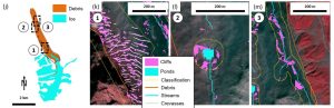
Ice cliff distribution plays a major role in determining the melt of debris-covered glaciers but its controls are largely unknown. We used 14 Pléiades images, the majority of which were provided by the Pléiades Glacier Observatory (PGO), to assemble a data set of 37,537 ice cliffs and determine their characteristics across 86 debris-covered glaciers within High Mountain Asia (HMA). This was made possible thanks to the combination of automated mapping routines applied to the atmospherically-corrected multi-spectral images, and the extraction of topographic information from the Digital Elevation Models (DEMs) derived from the Pléiades stereo pairs. We find that 38.9% of the cliffs are stream-influenced, 19.5% pond-influenced and 19.7% are crevasse-originated. Surface velocity is the main predictor of cliff distribution at both local and glacier scale, indicating its dependence on the dynamic state and hence evolution stage of debris-covered glacier tongues. Supraglacial ponds contribute to maintaining cliffs in areas of thicker debris, but this is only possible if water accumulates at the surface. Overall, total cliff density decreases exponentially with debris thickness as soon as the debris layer reaches a thickness of over 10 cm..

Kneib, M., Fyffe, C. L., Miles, E. S., Lindemann, S., Shaw, T. E., Buri, P., McCarthy, M., Ouvry, B., Vieli, A., Sato, Y., Kraaijenbrink, P. D. A., Zhao, C., Molnar, P., and Pellicciotti, F.: Controls on Ice Cliff Distribution and Characteristics on Debris-Covered Glaciers, Geophysical Research Letters, 50, e2022GL102444, https://doi.org/10.1029/2022GL102444, 2023.

Example of classification of ice cliffs from Kyzylsu Glacier, Tajikistan: 1/crevassed-areas, 2/pond-influenced cliffs and 3/stream-influenced cliffs, with the pictures (g–i) and Pléiades view (k–m) of the corresponding zones. Image credit: M. Kneib and E. S. Miles. Background of (k–m) is the Pléiades false-color multispectral image (19 September 2021). Pléiades © CNES 2021, Distribution AIRBUS DS

Plus d'actualités

Map of elevation changes: quick-looks

The ultimate PGO products are the maps of glacier elevation changes over 5-yr periods. They will soon be available on a web server. To keep you waiting, find below a gallery of such maps for 2016-2021, 2017-2022 or 2018-2023. Maybe you can spot your favorite glacier? [click on the first image to start the slideshow] […]

Mandal et al.: Glacier mass balance and its climatic and nonclimatic drivers in the Ladakh region during 2000–2021 from remote sensing data

Ladakh region in the western Himalaya relies heavily on meltwater from glaciers and snow covers, particularly during spring season and dry years, due to its arid climate conditions. In our recently published paper (reference below), we estimated the geodetic mass balance of nearly all Ladakh glaciers using SRTM and ASTER DEMs for the period 2000-2021. […]

A pre-print describing the PGO program is online for public discussion & review

We just submitted to The Cryosphere (EGU) a manuscript describing the Pléiades Glacier Observatory (PGO) initiative, the data provided to the community. An effort was made to assess the precision of the topographies and elevation change maps derived from these data, in particular using synchronous Lidar data from Norway and Canada. A pre-print is available […]

Rechercher