December 2022. D-1 before the launch of SWOT !
SWOT, the NASA/CNES high-resolution oceanographic and hydrological satellite mission, will make the first global survey of the Earth’s surface waters and of our changing oceans and coastal waters, over 90% of the Earth’s surface. LEGOS has been strongly involved in the scientific preparation of SWOT over the last decade, with 10 scientific projects dedicated to hydrology, oceanography and coastal applications. LEGOS scientists also organise the French scientific leadership : Jean-Francois Crétaux, CNES, (CNES hydrology Lead) and Rosemary Morrow, CNAP-University Toulouse III (CNES Oceanography Lead). SWOT launch is scheduled for December 15, 2022 !
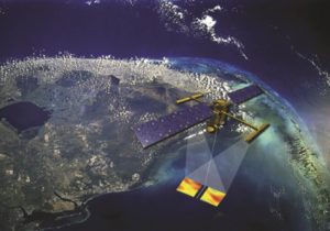
Schematic image of SWOT, with these wide swath measurements (credits NASA)
The SWOT (Surface Water and Ocean Topography) mission will bring together two scientific communities: oceanographers and hydrologists. It will measure the height in the Earth’s freshwater bodies and in the ocean, which will help understand how the ocean influences climate change, how global warming affects the global water cycle and water storage in lakes, rivers and reservoirs, and how communities can better prepare for disasters, such as floods.
For all altimeters launched to date, the measurements have always been made at the nadir of the satellite, so depending on the orbital cycle, the ground coverage is very uneven. When we create 2D maps, the ocean topography and derived currents can only be observed at scales larger than 100 km. Targeted lakes, for example, must be in the immediate vicinity of a track for a measurement to be made. For a river, only a few measurement points (sites called virtual stations), at the intersection between the ground track and the river are measurable. For a flooded area, only a few parts can be measured. With SWOT, which will operate on the principle of wide swath interferometry, the coverage will be truly global, and we can monitor in 2D smaller ocean dynamics down to 10 km in diameter, all lakes larger than 6 ha (around 2 million on Earth) and rivers larger than 100 meters. Moreover, this instrument will simultaneously measure not only the heights but also the contours of flooded areas (lake or river banks, floodplain boundaries) and thus water bodies, and, because of the continuous coverage, the slope of the water line. Thanks to these characteristics, derived products can be acquired with this satellite: ocean geostrophic currents at finer scales, water stock variations in lakes and floodplains, bathymetry, and discharges on continuous river reaches of 10 km (the flow velocity being related to the water line slope).
The first six months of the mission include a calibration and validation (CalVal) phase of the satellite, during which the satellite will fly in a one-day repeat orbit with reduced spatial coverage but improved temporal resolution. The first months of the SWOT mission represent a unique opportunity to follow the rapid evolution of ocean dynamics at fine scales (10-100 km), and of rapid lake and river variations. LEGOS is involved in all of the hydrology, oceanography and coastal components of SWOT.
Calibration / Validation work over lakes and rivers is an essential activity which will be carried out by Legos researchers. During the 3 months of the fast sampling phase we will lead several field work campaigns in cooperation with international colleagues. Over lake Issykkul in Kyrgyzstan, lakes in the Pyrénées, over the Amazon basin, the Maroni river in French Guyana, over the Ganges river in India or the Tsiribihna river in Madagascar. Geodetic instruments will be deployed at several sites as well as in situ gauges to assess the uncertainty for SWOT to measure water level, extent, volume changes on lakes, and level, slope and discharge on river.
Regional open ocean studies will be undertaken at LEGOS in the Southern Ocean, around New Caledonia, in the tropical Atlantic, and off the Brazil coast, studying fine-scale ocean dynamics and their interaction with tides, their impact on air-sea interactions and on biomass distribution. Coastal and estuarine studies are planned off the French Atlantic coast and Vietnam. Oceanographic in-situ campaigns to validate the SWOT observations and to understand the ocean dynamics at fine scales are planned off New Caledonia and off the Brazil coast in 2023.
The SWOT mission is a collaboration between the CNES and NASA – with contributions from the Canadian Space Agency (CSA) and the British Space Agency. The satellite was assembled, integrated and tested at the Thales Alenia Space facility in Cannes, France.
The launch of the Franco-American SWOT satellite is scheduled for Thursday, December 15, 2022, from Vandenberg Air Force Base in California at 12:46 p.m. CET (3:46 a.m. Pacific Standard Time). To allow as many people as possible to follow the launch of SWOT, CNES is producing a broadcast on its Twitch and YouTube channels starting at 12:15 p.m.
More information is available on the dedicated CNES website.
Contacts : rosemary.morrowNO SPAM -- FILTER@NO SPAM -- FILTERlegos.obs-mip.fr, jean-francois.cretauxNO SPAM -- FILTER@NO SPAM -- FILTERlegos.obs-mip.fr