ECHOS-en

December 2022. D-1 before the launch of SWOT !

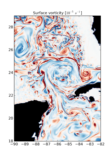
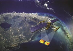
SWOT, the NASA/CNES high-resolution oceanographic and hydrological satellite mission, will make the first global survey of the Earth’s surface waters and of our changing oceans and coastal waters, over 90% of the Earth’s […]

14.12.2022

Models

Publisher: Direction– Updated on 24/03/2023 The role of numerical modeling in the laboratory Scientific computing and numerical modeling in particular take an increasing part in our activities, both as users […]

Satellites

Publisher: Direction– Updated on 27/05/2021 Satellite missions at LEGOS LEGOS uses space-based remote sensing for all of its major scientific themes: oceanography (offshore and coastal), hydrology, glaciology (polar and continental) […]

In situ observations

Publisher: Direction– Updated on 27/05/2021 In situ observation is a fundamental tool in the research conducted at LEGOS and in Earth sciences in general. It is the field truth and […]

ECHOS: Cryosphere and Hydrosphere Studies by Space Observations

Publisher: Direction – Updated on 31/03/2021 Scientific objectives The ECHOS team studies the different components of the water cycle from regional to global scales, and how these interact with climate […]

Space observations and analysis of sea ice volume change impacts

Name: Marion BOCQUET Start date: 2020/10/01 Thesis supervisor: Frédérique REMY Co-supervision 1: Sara FLEURY Co-supervision 2: Thomas MOREAU Keywords: Sea ice, Climate, Space altimetry

01.10.2020

Water cycle, Hydro-climatology and Water resources in theCongo River Basin: integrated approach using remote sensing, numerical modeling and in situ observations in the context of the SWOT mission

Name: Benjamin MAMBWE KITAMBO Start date: 2020/03/02 Thesis supervisor: Fabrice PAPA Co-supervision 1:  Adrien PARIS Co-supervision 2: Raphael TSHIMANGA MUAMBA Keywords: Congo River Basin, Surface and subsurface water storage, Evapotranspiration, […]

02.03.2020

Inversion of land surface properties (flood, soil moisture, biomass) using GNSS-R data from the CYGNSS mission

Name:  Pierre ZEIGER Start date:  2019/10/01 Thesis supervisor: Frédéric FRAPPART Co-supervision 1: José DARROZES Keywords: GNSS-R, Soil moisture, Biomass, Flooding, Tidal bore

01.10.2019

Global glacier mass loss. Improved estimates from remote sensing and modelling

Name: Romain HUGONNET Start date: 2018/11/01 Thesis supervisor: Etienne BERTHIER Co-supervision 1: Daniel FARINOTTI Keywords: Water resource, Glacier, Sea level, Mass balance

01.11.2018

Search